Fountains Abbey 5 Bridges walk
Fountains Abbey in Studley Royal Park is one of the most amazing Cistercian sites in the UK. This is a short walk of 3-5 miles depending where you start from and passes through the Studley Royal Estate on a public footpath for which is free to access; you do not need a ticket to follow this walk.
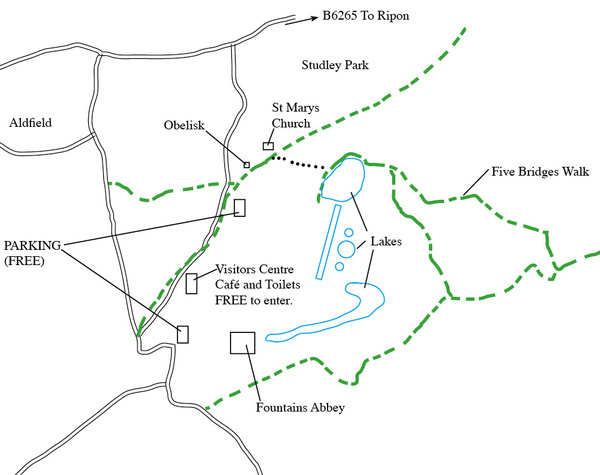
Take the B6265 road and Fountain's Abbey is signed from this road, about a mile out of Ripon. Following the sign will take you on one of the estate roads. You will pass the obelisk on your left and arrive at one of the car parks near the visitors centre (NB, this estate road is locked at 6.30 pm!). Walk back up this road and the footpath begins at a gate just before the obelisk. This footpath actually goes across the deer park but there are clear paths which run down to the lake where you can pick up the 5 bridges walk footpath. The grounds on this footpath are studded with beautiful ancient trees and woodland. The footpath goes around the edge of the lake, across the weir and then follows a wooded valley on the edge of the estate. For a longer walk, this footpath joins up with another that runs across the southern edge of the estate but will take you back to the car park.
To see a detailed OS map click on this link ( http://www.streetmap.co.uk/map.srf?X=428197&Y=468884&A=Y&Z=115 ) or use OS Landranger map 99; grid reference SE273683. About 40 minutes from York.
|

Also in: Photographic Walks in North Yorkshire
 |  |  |  |  |
 |  |  |  |  |
 |  |  |  |  |